- Interlaken Switzerland
- +41762950767
- info@swisslocalguide.ch
People often treat hiking like a casual afternoon activity — pick a trail, put on some shoes, go. In Switzerland, that attitude can get you into real trouble. The mountains here are high, the weather changes fast, and rescue helicopters cannot fly during a thunderstorm. Every summer, unprepared hikers end up stuck on ridges, exhausted on trails they underestimated, or caught in conditions they did not see coming.
None of this is meant to scare you away from hiking — it is meant to make your hike better. Understanding your own fitness level, choosing the right route, reading the weather, and packing properly are all connected. Get them right and you will have one of the best days of your trip. Get one of them wrong and it can turn uncomfortable fast.
If after reading this you still feel unsure, that is exactly why we started our company. You can join one of our guided hiking tours or book a private hiking guide and let us handle the planning entirely.
Probably the most common mistake hikers make is overestimating what they can handle. People get stuck in the mountains not because the trail was dangerous but because they chose a hike that was too long or too steep for their fitness level.
The simplest way to assess this is time. In Switzerland, trail signs do not show distance — they show how long it takes to reach the next point. This is because 5 km (3.1 miles) uphill and 5 km downhill are completely different efforts. The times shown on signs and apps are based on a below-average pace, so if you are reasonably fit you will likely finish faster. But if you look at a sign that says three and a half hours and honestly ask yourself whether you can walk that long with elevation change, and the answer is uncertain — choose a shorter route.
If you are hiking in a group, plan for the slowest member. Account for breaks, photos, and lunch. It is always better to finish with energy to spare than to push through the last hour exhausted.
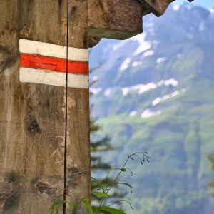
Switzerland has one of the best trail marking systems in Europe. It is simple once you know what to look for.
Every trail sign has a pointed tip, and the colour of that tip tells you the difficulty:
Yellow — Wanderweg. Easy walking paths, well-maintained, suitable for anyone in reasonable shape. No special equipment needed.
White-Red-White — Bergwanderweg. Mountain hiking trails. These can be steep, narrow, and exposed in places. You need proper hiking shoes, reasonable fitness, and some comfort with heights.
White-Blue-White — Alpinwanderweg. Alpine routes. These require proper gear, mountain experience, and often involve scrambling, snow crossings, or exposed ridgelines. If you are not an experienced hiker, avoid blue-marked trails entirely.
The best tool for planning your route is Switzerlandmobility — it shows every marked trail in Switzerland with difficulty, elevation, and estimated time. Study it before you go. Check the elevation profile, not just the distance. A trail that looks short on the map can involve 800 metres (2,600 feet) of climbing.
Weather in the mountains is unstable — that is the one rule that never changes. For a detailed month-by-month breakdown of what to expect, read our Interlaken weather guide. Here I will focus on what matters specifically for hikers.
Use more than one forecast source. I primarily use MeteoSwiss and Windy. Windy has a useful feature where you can compare different forecast models for the same location — when models disagree, expect uncertainty. Do not trust any forecast more than two days out for mountain weather. Check the evening before and again in the morning before you leave.
Rain and sudden temperature drops are uncomfortable but manageable if you are dressed properly. Thunderstorms are the real danger — especially in summer. South-facing cliffs warm up through the day and push hot air upward, which is exactly how thunderstorms form. They build energy through the afternoon, which is why they typically hit between 2 and 5 PM. This is also why locals start their hikes early in the morning — not because they love waking up at dawn, but because they want to be off the exposed ridges before the storms build.
If thunderstorms appear in the forecast, that does not automatically mean you should cancel. It means you should plan your route so that you are already descending or in a sheltered area by early afternoon. Check the hourly forecast to see when the risk window starts and build your timing around it.
Wind is easy to underestimate. It does not need to be a gale — even steady moderate wind on an exposed ridge for two or three hours will drain your energy and body heat. Check the wind forecast for your altitude, not just the valley. If you are heading above 2,000 metres (6,500 feet), wind is almost always a factor.
If you are unsure about reading a forecast for your planned hike, send us a message on WhatsApp — we are happy to help.
Water. Always carry more than you think you need. Switzerland has excellent access to drinking water — there are fountains in most valleys, farmers sometimes build them along trails, and mountain streams are generally drinkable. But do not rely on this alone. Many hikes have long stretches with no water at all, especially if the summer has been dry. Check the map before you go and plan where you can refill.
Food. Look at the map for mountain huts along your route — many of them cook traditional Swiss meals on the spot and serve basic drinks. But check whether they are actually open before counting on them. Regardless of whether you plan to stop at a hut, always carry extra food. Muesli bars, protein bars, or dried fruit weigh almost nothing and can make a real difference if your hike takes longer than expected.
Clothing. This comes down to altitude — temperature drops roughly 0.65°C (about 1°F) for every 100 metres (330 feet) you climb. Layering is the best approach. Bring a warm mid-layer and a waterproof, windproof outer jacket even on sunny days. One tip from experience — a dry pair of socks weighs almost nothing but can be a game changer if your feet get wet from a stream crossing or unexpected rain.
Sun protection. Sunglasses, sunscreen, and a hat are not optional at altitude. UV exposure increases significantly with elevation — at 2,500 metres (8,200 feet) it is roughly 30% stronger than at sea level. Sun stroke without a head cover is a real risk, not a theoretical one.
Switzerland’s mountain transportation is world-class, and many hikers plan routes that use a cable car or train for part of the journey. Here is the advice most people get backwards: it is always better for your body to hike up and take the cable car down, not the other way around.
Hiking downhill puts enormous stress on your knees, ankles, and quadriceps — far more than going uphill. From experience, people who ride up and hike down end up with aching legs for days afterwards. If you hike up, your muscles warm gradually and the cable car ride down gives them a break when they need it most.
If you are planning a ridge hike — ride up, walk the ridge, ride down if possible. That gives you the best of everything without the punishment of a long descent.
One important thing to know: most mountain cable cars and gondolas close around 5 PM, sometimes earlier. Check the exact schedule before you start your hike and plan backwards from the last descent. Getting stranded at the top because you missed the last car is more common than you might think.
If you would prefer to have someone experienced handle all of this planning for you, that is exactly what our private guide service is designed for. You tell us what kind of day you want and we take care of the rest.